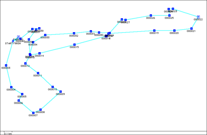
Bildstock Volksmarch GPS Points
Location
Bildstock is between Saarbrucken and Kaiserslautern, Germany. The start is at the Pausenhalle Hoferkopfschule Bildstock. Length
They have a 6, 10 and 20 km.Trail Quality
The route was nice with the trail almost exclusively in the forest. The trail was well marked and could easily accommodate a stroller. The elevation change was only a few hundred feet. Map
ID
Name
Comment
Date Time
Latitude
Longitude
Icon
Display Option
Altitude
R
1
BILDSTOCK
W
PARKING
WAYPOINT
07/29/2003 11:51:36
49.33485
7.10485
Parking Area
NS
W
START FINISH
WAYPOINT
07/29/2003 11:51:36
49.33438
7.10393
Trail Head
NS
W
000003
WAYPOINT
07/29/2003 11:51:36
49.33165
7.10275
Waypoint
NS
W
000004
WAYPOINT
07/29/2003 11:51:36
49.32918
7.10363
Waypoint
NS
W
000005
WAYPOINT
07/29/2003 11:51:36
49.32840
7.10552
Waypoint
NS
W
000006
WAYPOINT
07/29/2003 11:51:36
49.32768
7.10493
Waypoint
NS
W
000007
WAYPOINT
07/29/2003 11:51:36
49.32630
7.10743
Waypoint
NS
W
000008
WAYPOINT
07/29/2003 11:51:36
49.32665
7.10868
Waypoint
NS
W
000009
WAYPOINT
07/29/2003 11:51:36
49.32868
7.11212
Waypoint
NS
W
000010
WAYPOINT
07/29/2003 11:51:36
49.32923
7.11077
Waypoint
NS
W
000011
WAYPOINT
07/29/2003 11:51:36
49.33078
7.10822
Waypoint
NS
W
000012
WAYPOINT
07/29/2003 11:51:36
49.33187
7.10608
Waypoint
NS
W
000013
WAYPOINT
07/29/2003 11:51:36
49.33282
7.10690
Waypoint
NS
W
000014
WAYPOINT
07/29/2003 11:51:36
49.33300
7.10848
Waypoint
NS
W
000015
WAYPOINT
07/29/2003 11:51:36
49.33398
7.11453
Waypoint
NS
W
000016
WAYPOINT
07/29/2003 11:51:36
49.33495
7.11997
Waypoint
NS
W
000017
CONTROL POINT
07/29/2003 11:51:36
49.33495
7.11998
Information
NS
W
000018
WAYPOINT
07/29/2003 11:51:36
49.33523
7.12038
Waypoint
NS
W
000019
WAYPOINT
07/29/2003 11:51:36
49.33555
7.12828
Waypoint
NS
W
000020
WAYPOINT
07/29/2003 11:51:36
49.33555
7.13173
Waypoint
NS
W
000021
WAYPOINT
07/29/2003 11:51:36
49.33578
7.13467
Waypoint
NS
W
000022
CONTROL POINT
07/29/2003 11:51:36
49.33708
7.13585
Information
NS
W
000023
WAYPOINT
07/29/2003 11:51:36
49.33800
7.13148
Waypoint
NS
W
000024
WAYPOINT
07/29/2003 11:51:36
49.33798
7.13073
Waypoint
NS
W
000025
WAYPOINT
07/29/2003 11:51:36
49.33725
7.13087
Waypoint
NS
W
000026
WAYPOINT
07/29/2003 11:51:36
49.33725
7.12765
Waypoint
NS
W
000027
WAYPOINT
07/29/2003 11:51:36
49.33677
7.12332
Waypoint
NS
W
000028
WAYPOINT
07/29/2003 11:51:36
49.33680
7.12265
Waypoint
NS
W
000029
WAYPOINT
07/29/2003 11:51:36
49.33528
7.12057
Waypoint
NS
W
000030
WAYPOINT
07/29/2003 11:51:36
49.33533
7.11872
Waypoint
NS
W
000031
WAYPOINT
07/29/2003 11:51:36
49.33547
7.11733
Waypoint
NS
W
000032
WAYPOINT
07/29/2003 11:51:36
49.33525
7.11445
Waypoint
NS
W
000033
WAYPOINT
07/29/2003 11:51:36
49.33505
7.10950
Waypoint
NS
W
000034
WAYPOINT
07/29/2003 11:51:36
49.33425
7.10738
Waypoint
NS
W
000035
WAYPOINT
07/29/2003 11:51:36
49.33290
7.10683
Waypoint
NS
W
000036
WAYPOINT
07/29/2003 11:51:36
49.33457
7.10665
Waypoint
NS
W
000037
WAYPOINT
07/29/2003 11:51:36
49.33568
7.10788
Waypoint
NS
W
000038
WAYPOINT
07/29/2003 11:51:36
49.33582
7.10847
Waypoint
NS
W
000039
WAYPOINT
07/29/2003 11:51:36
49.33573
7.10725
Waypoint
NS
W
000040
WAYPOINT
07/29/2003 11:51:36
49.33463
7.10523
Waypoint
NS
W
START FINISH
WAYPOINT
07/29/2003 11:51:36
49.33438
7.10393
Trail Head
NS
W
PARKING
WAYPOINT
07/29/2003 11:51:36
49.33485
7.10485
Parking Area
NS